


Pipeline
Surveying
We are on the forefront of survey technology through our drone survey program and team of professional land surveyors with decades of experience utilizing state-of-the-art technology, including traditional & drone surveying Matrice 600 Pros equipped with Zenmuse Cameras and Velodyne LiDAR units.
Traditional Surveying
If your next project has the need for land surveys, I3 Engineering has the solution. Our team of professional land surveyors has decades worth of experience in utility line surveys, property boundary surveys, topographic surveys and bathometric surveys of rivers and streams. We can dispatch survey crews of two, three or four people depending on the project needs. We have surveyed thousands of miles of utility line rights-of-way and thousands of acres of topography. We own a vast array of survey equipment from total station units to submeter handheld and RTK GPS units.
With the Trimble X7, our surveyors have the ability to capture accurate scans of existing piping and equipment with an accuracy of 1-3 millimeters. The geo-referenced data can be captured both indoors and outdoors. It can also be used to capture data in dangerous areas, such as confined spaces or busy intersections, without putting personnel in harm’s way. Our surveyors can view the data real-time using the Trimble T-10 Tablet, to ensure that all the data requested by the client is collected. The data can then be used to create a point cloud for use in Autocad, or a 360-degree photo from which measurements can be taken.
We also have two Carlson BXR7 base/rover units which possess the capability of utilizing four satellite constellations. With this technology, survey grade positions can be taken by the GPS units within seconds, even with tree cover and in mountainous terrain. With all of these tools, we can select the right equipment and crew size to get your survey completed with the minimal amount of time in the field and in the most cost-effective manner.
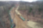
Drone Surveying
I3 Engineering is on the forefront of survey technology through our drone survey program. I3 Engineering has invested in several Matrice 600 Pro drones that are outfitted to carry advanced survey equipment. With these drones, I3 Engineering can complete surveys of pipeline rights-of-way and large tracts of land in a fraction of the time traditional methods would take. The Matrice 600 Pro seen in the video above has a maximum payload of 12 lbs. It can reach top speeds of 40 mph. The drone's flight controller contains algorithms that allow for triple redundancy of positional accuracy by comparing signals from three sets of GNSS units.
I3 Engineering has loaded out our drone with a Zenmuse camera and a Velodyne LiDAR unit. The Zenmuse camera provides color photography of the survey area that can be used as a background for drawings, maps, etc. It is also capable of capturing video. The Velodyne LiDAR unit will capture 300,000 topographic points per second enabling I3 Engineering's surveyors to gather millions of topographic shots in just a few minutes! This data can then be transferred into our 3D modeling systems for generation of topography maps, cuts, fills, etc. In short, this tool enables I3 Engineering to complete large survey jobs quickly and efficiently, saving our customers time and money.
We've expanded our drone fleet with the addition of the Inspired Flight 1200A! This DOD approved Blue-list hexacopter has a wing span of 65 inches and a payload capacity of over 19 pounds. Equipped with the our new Survey32 LiDAR system and a Sony A6000 24 megapixel camera, the IF1200A has double the flight time and twice as many lasers as any other drone in our fleet. With its ability to fly higher, faster, and longer, the IF 1200A can provide canopy penetrating topographic data on a 200 acre site in just one flight. The data can then be easily transformed into a 3D color point cloud for use in CAD for site design and grading.
View projects featuring this service:


